Sala Comacina
Sala Comacina is a transport stop in Sala Comacina, Province of Como, Lombardy which is located on Strada statale 340 Regina. Sala Comacina is situated nearby to Piazza Giorgio Giacosa, as well as near the square Piazza Piero Caprani.| Tap on a place to explore it |
Places of Interest Nearby
Highlights include Isola Comacina and Chiesa di San Bartolomeo.
Isola Comacina

Photo: Daniel Case, CC BY-SA 3.0.
The Comacina Island is the unique island of Lake Como, near Tremezzina. Sights include seven churches built by the ancient Byzantines, secluded corners and the open views.
Chiesa di San Bartolomeo
Church

Photo: Yiyi, CC BY-SA 4.0.
Chiesa di San Bartolomeo is a church, which is situated 300 metres north of Sala Comacina.
Santi Giacomo e Filippo
Church

Photo: Ottantafame, CC BY-SA 4.0.
Santi Giacomo e Filippo is a church, which is situated 760 metres northeast of Sala Comacina.
Places in the Area
Nearby places include Ossuccio and Lenno.
Ossuccio
Village

Photo: Daniel Case, CC BY-SA 3.0.
Ossuccio is a comune in the Province of Como in the Italian region Lombardy. It is located on the western shore of Lake Como some 20 kilometres northeast of Como.
Lenno
Village
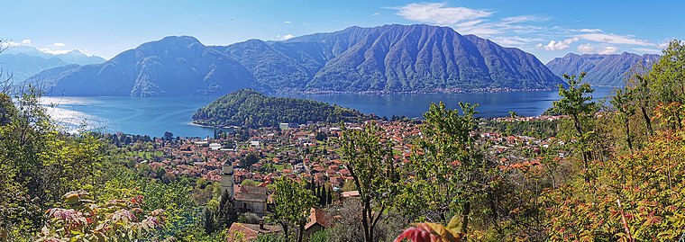
Photo: Kaitu, CC BY-SA 4.0.
Lenno was a comune in the Province of Como in the Italian region Lombardy, located about 60 kilometres north of Milan and about 20 kilometres northeast of Como.

Sala Comacina
- Type: Transport stop
- Address: Strada statale 340 Regina 53, Sala Comacina, 22010
- Categories: passenger ship terminal and transportation
- Location: Sala Comacina, Province of Como, Lombardy, Northwest Italy, Italy, Europe
- View on OpenStreetMap
Latitude
45.96367° or 45° 57′ 49″ northLongitude
9.16743° or 9° 10′ 3″ eastOperator
Navigazione LaghiOpen location code
8FQFX578+FXOpenStreetMap ID
node 1863254706OpenStreetMap feature
amenity=ferry_terminalOpenStreetMap feature
public_transport=stop_position
This page is based on OpenStreetMap, Wikidata, and Wikimedia Commons.
We’d love your help improving our open data sources. Thank you for contributing.
Satellite Map
Discover Sala Comacina from above in high-definition satellite imagery.
Places with the Same Name
Discover other places named “Sala Comacina”.
Notable Places Nearby
Highlights include Piazza Giorgio Giacosa and Piazza Piero Caprani.
Nearby Places
Explore places such as Taverna Bleu and Benvenuti a Sala Comacina.
Lombardy: Must-Visit Destinations
Delve into Milan, Bergamo, Brescia, and Mantua.
Curious Transport Stops to Discover
Uncover intriguing transport stops from every corner of the globe.
About Mapcarta. Data © OpenStreetMap contributors and available under the Open Database License". Text is available under the CC BY-SA 4.0 license, except for photos, directions, and the map. Photo: Wiki rkit, CC BY-SA 4.0.