Ribbons and Roses
Ribbons and Roses is a party shop in Morecambe, Lancaster, England which is located on Queen Street. Ribbons and Roses is situated nearby to the community center The Rainbow Centre, as well as near the amusement arcade Seagull Amusements.| Tap on a place to explore it |
Places of Interest Nearby
Highlights include Morecambe railway station and Morecambe Winter Gardens.
Morecambe railway station
Railway station

Photo: roger geach, CC BY-SA 2.0.
Morecambe is a railway station on the Morecambe Branch Line, which runs between Lancaster and Heysham Port. The station, situated 4 miles west of Lancaster, serves the town of Morecambe in Lancashire. It is owned by Network Rail and managed by Northern Trains. Morecambe railway station is situated 1,400 feet southwest of Ribbons and Roses.
Morecambe Winter Gardens
Theater building

Photo: Phantom56798, CC BY-SA 4.0.
The Winter Gardens is a Grade II* listed building in Morecambe, Lancashire, England. Designed by architects Mangnall and Littlewood, with Frank Matcham as a consulting architect, it was originally built as the Victoria Pavilion Theatre in 1897 and was an extension to the existing Winter Gardens complex, which has since been demolished. Morecambe Winter Gardens is situated 1,500 feet west of Ribbons and Roses.
St Laurence’s Church
Church
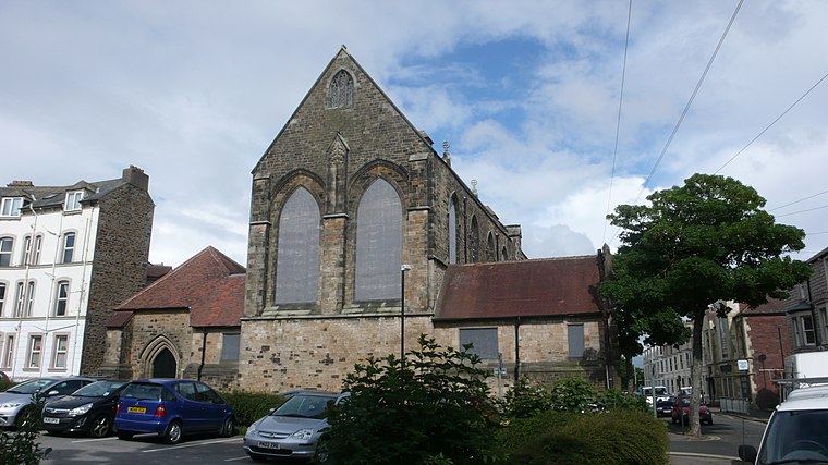
Photo: flipflopnick, CC BY-SA 3.0.
St Laurence's Church stands at the corner of Chapel Street and Edward Street in Morecambe, Lancashire, England. It is a redundant church, formerly an Anglican parish church. St Laurence’s Church is situated 1,100 feet southwest of Ribbons and Roses.
Places in the Area
Nearby places include Poulton-le-Sands and Torrisholme.
Poulton-le-Sands
Neighborhood

Photo: Alexander P Kapp, CC BY-SA 2.0.
Poulton-le-Sands is one of three small villages that combined to create Morecambe, Lancashire, England, the other two being Torrisholme and Bare. A local board of health was established in 1852, which, taking its name from Morecambe Bay, became the borough of Morecambe in 1902.
Torrisholme
Suburb

Photo: Ian Taylor, CC BY-SA 2.0.
Torrisholme is a suburb of Morecambe, Lancashire, on the North West coast of England. In the 2001 census, the Torrisholme Ward had a population of 6,758 living in 3,118 households, decreasing marginally to 6,755 at the 2011 Census.
Heysham
Town

Photo: Rwendland, Public domain.
Heysham is a coastal village in the Lancaster district of Lancashire, England, overlooking Morecambe Bay. It is a ferry port, with services to the Isle of Man and Ireland, and the site of two nuclear power stations. Heysham is situated 2 miles southwest of Ribbons and Roses.
Ribbons and Roses
- Type: Party shop
- Address: Queen Street, Morecambe, LA4 5EG
- Category: shop
- Location: Morecambe, Lancaster, Lancashire, North West England, England, United Kingdom, Britain and Ireland, Europe
- View on OpenStreetMap
Latitude
54.07312° or 54° 4′ 23″ northLongitude
-2.86418° or 2° 51′ 51″ westOpen location code
9C6V34FP+68OpenStreetMap ID
node 3959652860OpenStreetMap feature
shop=party
This page is based on OpenStreetMap, Wikidata, and Wikimedia Commons.
We’d love your help improving our open data sources. Thank you for contributing.
Satellite Map
Discover Ribbons and Roses from above in high-definition satellite imagery.
Notable Places Nearby
Highlights include The Rainbow Centre and Seagull Amusements.
Nearby Places
Explore places such as The Masons and Nowhere.
Lancashire: Must-Visit Destinations
Delve into Blackpool, Blackburn, Preston, and Burnley.
Curious Party Shops to Discover
Uncover intriguing party shops from every corner of the globe.
About Mapcarta. Data © OpenStreetMap contributors and available under the Open Database License". Text is available under the CC BY-SA 4.0 license, except for photos, directions, and the map. Photo: matthewhartley369, CC BY-SA 2.0.