James Robb Avenue
James Robb Avenue is a bus stop in Fife, North East Scotland, Scotland. James Robb Avenue is situated nearby to St Andrews Police Station, as well as near St Andrews Fire Station.| Tap on a place to explore it |
Places of Interest Nearby
Highlights include St Andrews Community Hospital and St Andrews Cathedral.
St Andrews Community Hospital
Hospital
St Andrews Community Hospital is a small hospital to the south of the university town of St Andrews in Fife, Scotland. The hospital serves the town of St Andrews and surrounding villages in North East Fife and is managed by NHS Fife. St Andrews Community Hospital is situated 1,600 feet southwest of James Robb Avenue.
St Andrews Cathedral
Ruins

Photo: KPapageorgiou, CC BY-SA 4.0.
The Cathedral of St Andrew is a ruined cathedral in St Andrews, Fife, Scotland. It was built in 1158 and became the centre of the Medieval Catholic Church in Scotland as the seat of the Archdiocese of St Andrews and the Bishops and Archbishops of St Andrews. St Andrews Cathedral is situated 4,200 feet northeast of James Robb Avenue.
St Andrews Castle
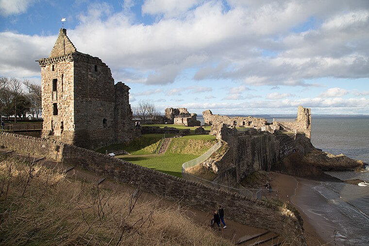
Photo: ArchHist, CC BY-SA 4.0.
St Andrews Castle is a ruin located in the coastal Royal Burgh of St Andrews in Fife, Scotland. The castle sits on a rocky promontory overlooking a small beach called Castle Sands and the adjoining North Sea. St Andrews Castle is situated 1 mile northeast of James Robb Avenue.
Places in the Area
Nearby places include St Andrews and Strathkinness.
St Andrews

Photo: Wikimedia, Public domain.
St Andrews is a town on the coast of Fife in northeast Scotland. With a population of 16,930 in 2021, it's an attractive place famous for its ancient university and as the "home of golf".
Strathkinness
Village
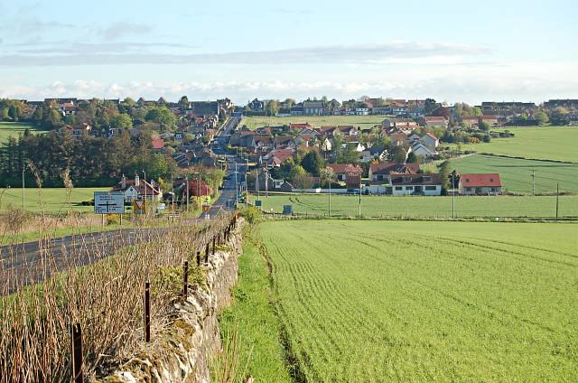
Photo: Jim Bain, CC BY-SA 2.0.
Strathkinness is a small village located 3 miles to the west of St Andrews in North East Fife. A key characteristic of the village is the newly developed housing in the centre of the village. Strathkinness is situated 3 miles west of James Robb Avenue.
Dunino
Hamlet

Photo: Wikimedia, CC BY-SA 2.0.
Dunino is a village and parish in the East Neuk of Fife. It is 10 km from the nearest town, St Andrews, and 8 km from the fishing village of Anstruther. Dunino is situated 3½ miles southeast of James Robb Avenue.
James Robb Avenue
- Type: Bus stop
- Category: transportation
- Location: Fife, North East Scotland, Scotland, United Kingdom, Britain and Ireland, Europe
- View on OpenStreetMap
Latitude
56.33107° or 56° 19′ 52″ northLongitude
-2.8005° or 2° 48′ 2″ westOpen location code
9C8V85JX+CROpenStreetMap ID
node 4216237573OpenStreetMap feature
highway=bus_stopOpenStreetMap feature
public_transport=platform
This page is based on OpenStreetMap, Wikidata, and Wikimedia Commons.
We’d love your help improving our open data sources. Thank you for contributing.
Satellite Map
Discover James Robb Avenue from above in high-definition satellite imagery.
Notable Places Nearby
Highlights include St Andrews Police Station and St Andrews Fire Station.
Nearby Places
Explore places such as Spar and Maxin.
Fife: Must-Visit Destinations
Delve into Dunfermline, St Andrews, Kirkcaldy, and Glenrothes.
Curious Bus Stops to Discover
Uncover intriguing bus stops from every corner of the globe.
About Mapcarta. Data © OpenStreetMap contributors and available under the Open Database License". Text is available under the CC BY-SA 4.0 license, except for photos, directions, and the map. Photo: AlasdairW, CC BY-SA 3.0.