SUP MIGUEL MOLANO
SUP MIGUEL MOLANO is a supermarket in Rafael Uribe Uribe, Bogotá D.C., Bogotá which is located on Calle 28 Sur. SUP MIGUEL MOLANO is situated nearby to the historic site Corporación IPS Corvesalud Coodontólogos, as well as near the stadium Estadio Olaya Herrera.| Tap on a place to explore it |
Places of Interest Nearby
Highlights include Centro Mayor and SENA.
Centro Mayor
Shopping center

Photo: EEIM, CC BY-SA 4.0.
Centro Mayor is a shopping mall located in the south of Bogotá, Colombia. It was inaugurated on March 26, 2010. The mall has 248,000 m2 of built area, being the biggest mall in Colombia and the second one in Latin America, behind the Centro Comercial Aricanduva, in São Paulo, Brazil. Centro Mayor is situated 2 km northwest of SUP MIGUEL MOLANO.
SENA
Bus station

Photo: EEIM, CC BY-SA 3.0.
The simple station SENA is part of the TransMilenio mass-transit system of Bogotá, Colombia, opened in the year 2000. SENA is situated 1½ km north of SUP MIGUEL MOLANO.
Casa de Nariño
Government office
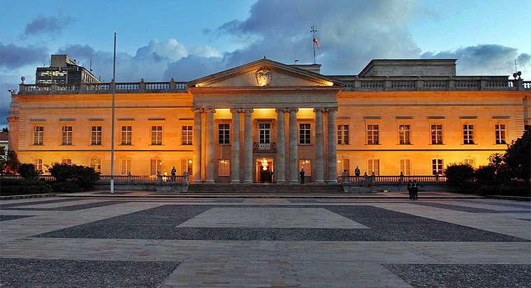
Photo: Juanjo70000, CC BY-SA 4.0.
The Casa de Nariño, literally the House of Nariño, is the official residence and principal workplace of the President of Colombia. It houses the main office of the executive branch and is located in the capital city of Bogotá, Colombia. Casa de Nariño is situated 4 km east of SUP MIGUEL MOLANO.
Places in the Area
Nearby places include Quiroga and Antonio Nariño.
Antonio Nariño
Suburb

Photo: Pedro Felipe, CC BY-SA 4.0.
Antonio Nariño is the 15th locality of Bogotá, capital of Colombia. It is located in the central part of the city. This district is mostly inhabited by middle class residents.
South Bogotá

Photo: Pedro Felipe, CC BY-SA 3.0.
The South is a large area comprising six localities of Bogota. This area tends to be where the majority of the city's low-income and middle-working classes live.
SUP MIGUEL MOLANO
- Type: Supermarket
- Address: 22-26 Calle 28 Sur
- Categories: shop and food
- Location: Rafael Uribe Uribe, Bogotá D.C., Bogotá, Andino, Colombia, South America
- View on OpenStreetMap
Latitude
4.58251° or 4° 34′ 57″ northLongitude
-74.10994° or 74° 6′ 36″ westOpen location code
67P7HVMR+22OpenStreetMap ID
node 5011315325OpenStreetMap feature
shop=supermarket
This page is based on OpenStreetMap, Wikidata, and Wikimedia Commons.
We’d love your help improving our open data sources. Thank you for contributing.
Satellite Map
Discover SUP MIGUEL MOLANO from above in high-definition satellite imagery.
In Other Languages
“SUP MIGUEL MOLANO” goes by many names.
- Spanish: “SUP MIGUEL MOLANO”
Notable Places Nearby
Highlights include Corporación IPS Corvesalud Coodontólogos and Estadio Olaya Herrera.
Nearby Places
Explore places such as Virrey Solís I.P.S. and Prodenco.
Bogotá: Must-Visit Destinations
Delve into La Candelaria, Zona Rosa, Santa Fé-Los Mártires, and Usaquén.
Curious Supermarkets to Discover
Uncover intriguing supermarkets from every corner of the globe.
About Mapcarta. Data © OpenStreetMap contributors and available under the Open Database License". Text is available under the CC BY-SA 4.0 license, except for photos, directions, and the map. Photo: Wikimedia, CC BY-SA 3.0.