Selimbey
Selimbey is a suburb in Tuşba, Van Province. Selimbey is situated nearby to the suburb Abdurrahmangazi, as well as near Altıntepe.| Tap on a place to explore it |
Places of Interest
Highlights include Van Castle and Van Museum.
Van Castle
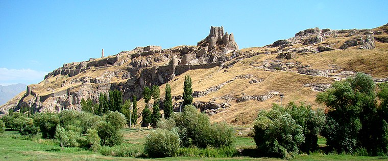
Photo: Uspn, CC BY-SA 3.0.
The Fortress of Van is a massive stone fortification built by the ancient kingdom of Urartu during the 9th to 7th centuries BC, and is the largest example of its kind.
Van Museum
Museum

Photo: Clemens Schmillen, CC BY-SA 4.0.
The Van Museum or Urartu Museum is a museum located in the city of Van in eastern Turkey. It showcases on 13,000 m2 a large archaeological and ethnographic record of human life and cultural development in the lake Van region from eastern Anatolia’s Stone Age to the present.
Van railway station
Railway station

Photo: Babbsack, CC BY-SA 3.0.
Van railway station is the main railway station in Van, Turkey. Up until July 2015, the Trans-Asia Express, from Tehran, Iran, stopped at the station. The train would continue to the Van Pier, where passengers would travel to Tatvan via ferry, and the western half of the train would continue to Ankara. Van railway station is situated 2½ km northeast of Selimbey.
Places in the Area
Nearby places include Van and İpekyolu.
Van

Photo: Bahoz, CC BY-SA 3.0.
Van is a city in Eastern Anatolia, Turkey. For Turks from the other regions of Turkey, it has a surprising beach resort feel in an area where their country is farthest from the sea.
İpekyolu
Town
İpekyolu is a municipality and district of Van Province, Turkey. Its area is 956 km2, and its population is 348,046. The district İpekyolu was created at the 2013 reorganisation from part of the former central district of Van, along with the new district Tuşba. İpekyolu is situated 3½ km east of Selimbey.
Toprakkale
Locality

Photo: EvgenyGenkin, CC BY 2.5.
Rusahinili ", modern Toprakkale, is an ancient Urartian fortress built by Rusa I, located near the modern city of Van in eastern Turkey. The site has been excavated by archaeological teams from Germany, the United Kingdom, and other countries. Toprakkale is situated 4 km east of Selimbey.
Selimbey
- Type: Suburb
- Also known as: “Selimbey Mah.”
- Categories: mahalle and locality
- Location: Tuşba, Van Province, Turkey, Middle East, Asia
- View on OpenStreetMap
Latitude
38.50937° or 38° 30′ 34″ northLongitude
43.3575° or 43° 21′ 27″ eastOpen location code
8HC5G954+PXOpenStreetMap ID
node 8596126067OpenStreetMap feature
place=suburbWikidata ID
Q109960832
This page is based on OpenStreetMap, Wikidata, and Wikimedia Commons.
We’d love your help improving our open data sources. Thank you for contributing.
Satellite Map
Discover Selimbey from above in high-definition satellite imagery.
In Other Languages
From Chechen to Turkish—“Selimbey” goes by many names.
- Chechen: “Селимбей”
- Tatar: “Селимбей”
- Turkish: “Selimbey, İpekyolu”
- Turkish: “Selimbey”
Places with the Same Name
Discover other places named “Selimbey”.
Localities in the Area
Explore places such as Abdurrahmangazi and Altıntepe.
Notable Places Nearby
Highlights include Can Kedi Evi and KEDİ EVİ.
Turkey: Must-Visit Destinations
Delve into Istanbul, Edirne, Ankara, and Izmir.
Curious Suburbs to Discover
Uncover intriguing suburbs from every corner of the globe.
About Mapcarta. Data © OpenStreetMap contributors and available under the Open Database License". Text is available under the CC BY-SA 4.0 license, except for photos, directions, and the map. Photo: Moonik, CC BY-SA 3.0.