Rosemount
Rosemount is a farm in Orkney Islands, Scotland. Rosemount is situated nearby to the locality Yesnaby, as well as near the village Harray.| Tap on a place to explore it |
Places of Interest Nearby
Highlights include Ring of Brodgar and Burrian,broch W shore of Loch of Harray.
Ring of Brodgar
Heath
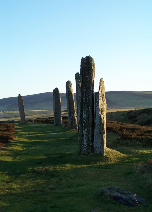
Photo: Otter, CC BY-SA 3.0.
The Ring of Brodgar is a Neolithic henge and stone circle about 6 miles north-east of Stromness on Mainland, the largest island in Orkney, Scotland. It is part of the UNESCO World Heritage Site known as the Heart of Neolithic Orkney. Ring of Brodgar is situated 2½ miles southeast of Rosemount.
Burrian,broch W shore of Loch of Harray
Archaeological site

Photo: Adam Ward, CC BY-SA 2.0.
Burrian,broch W shore of Loch of Harray is an archaeological site, which is situated 1¼ miles southeast of Rosemount.
Loch of Skaill

Photo: John Ireland, CC BY-SA 2.0.
The Loch of Skaill is a small somewhat triangular, freshwater loch in the parish of Sandwick, Orkney on Mainland Orkney, Scotland. It lies 0.5 mi south east of the Bay of Skaill close to Skaill House and the World Heritage neolithic site Skara Brae. Loch of Skaill is situated 2 miles northwest of Rosemount.
Places in the Area
Nearby places include Yesnaby and Harray.
Yesnaby
Locality

Photo: Renata, Public domain.
Yesnaby is a historic township in Sandwick, on the west coast of Orkney Mainland, Scotland, south of Skara Brae. It is renowned for its spectacular Old Red Sandstone coastal cliff scenery which includes sea stacks, blowholes, geos and frequently boiling seas. Yesnaby is situated 2½ miles west of Rosemount.
Harray
Village
Photo: Wikimedia, CC BY-SA 2.0.
Harray is an Orcadian parish and village on Mainland, Orkney, Scotland, United Kingdom. The village is near the Loch of Harray and was used by the Vikings for waterway transportation and Old Norse was spoken in the area up until the 1700s. Harray is situated 3 miles east of Rosemount.
Dounby
Village

Photo: Stephen McKay, CC BY-SA 2.0.
Dounby is a village on Mainland in Orkney, in the north of Scotland. Dounby village is situated at the crossroads of what are now the A986 and B9057, and has grown close to the meeting point of the three parishes of Sandwick, Birsay and Harray. Dounby is situated 3 miles northeast of Rosemount.
Rosemount
- Type: Farm
- Category: agriculture
- Location: Orkney Islands, Scotland, United Kingdom, Britain and Ireland, Europe
- View on OpenStreetMap
Latitude
59.02956° or 59° 1′ 46″ northLongitude
-3.27336° or 3° 16′ 24″ westOpen location code
9CFR2PHG+RMOpenStreetMap ID
way 1049341628OpenStreetMap feature
landuse=farmyard
This page is based on OpenStreetMap, Wikidata, and Wikimedia Commons.
We’d love your help improving our open data sources. Thank you for contributing.
Satellite Map
Discover Rosemount from above in high-definition satellite imagery.
Places with the Same Name
Discover other places named “Rosemount”.
Notable Places Nearby
Highlights include Site of Medieval chapel and burial ground and Shennar Howe.
Nearby Places
Explore places such as Doehouse and Feaval.
Orkney Islands: Must-Visit Destinations
Delve into Kirkwall, Stromness, Hoy, and Shapinsay.
Curious Farms to Discover
Uncover intriguing farms from every corner of the globe.
About Mapcarta. Data © OpenStreetMap contributors and available under the Open Database License". Text is available under the CC BY-SA 4.0 license, except for photos, directions, and the map. Photo: Massimo Telò, CC BY-SA 3.0.