Az Zirah Light
Az Zirah Light is a lighthouse in South Governorate, Lebanon. Az Zirah Light is situated nearby to the islet جزيرة الزيرة, as well as near Al Zira Island.| Tap on a place to explore it |
Photo: MARTYR-92, CC BY-SA 3.0.
Places of Interest Nearby
Highlights include Sidon Sea Castle and Melkite Greek Catholic Archeparchy of Sidon.
Sidon Sea Castle
Castle
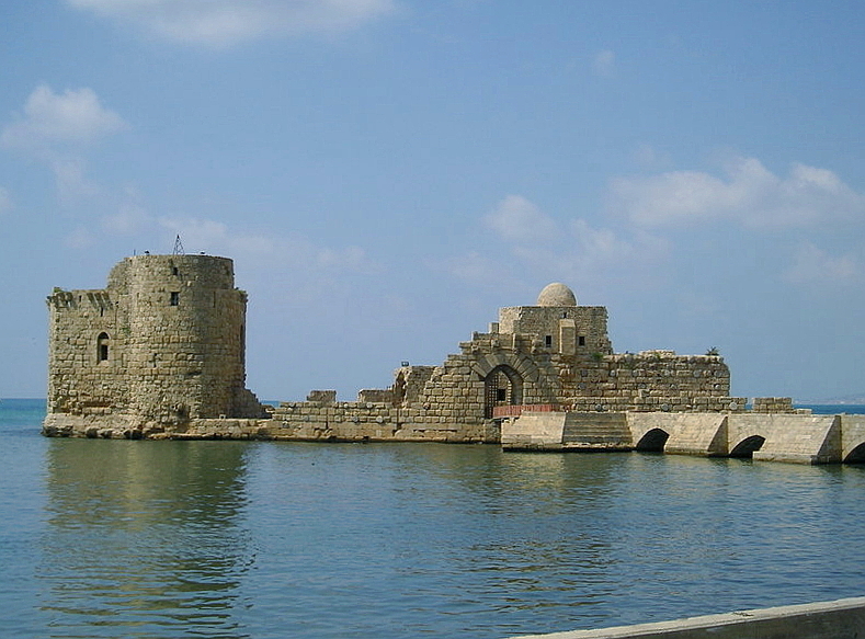
Photo: Heretiq, CC BY-SA 2.5.
Sidon's Sea Castle was built by the crusaders in the thirteenth century as a fortress of the Holy Land. It is one of the most prominent historical sites in the port city of Sidon, Lebanon. Sidon Sea Castle is situated 590 metres southeast of Az Zirah Light.
Melkite Greek Catholic Archeparchy of Sidon
Church
Melkite Greek Catholic Archeparchy of Sidon is a diocese of the Melkite Greek Catholic Church suffragan of the Melkite Greek Catholic Archeparchy of Tyre. Melkite Greek Catholic Archeparchy of Sidon is situated 1 km southeast of Az Zirah Light.
Sidon Soap Museum
Museum

Photo: BlingBling10, CC BY-SA 3.0.
The Soap Museum is a museum based in a historic soap factory in Sidon, Lebanon specialized in Levantine soaps. It opened in November 2000 and is managed by the Audi Foundation. Sidon Soap Museum is situated 1 km south of Az Zirah Light.
Places in the Area
Nearby places include Sidon and Hlaliyeh Saida.
Sidon

Photo: Peripitus, CC BY-SA 3.0.
Sidon is a city in Lebanon. The people are largely Sunni Muslims. The main attraction of Sidon is its Sea Castle, built by the Crusaders in the 13th century.
Hlaliyeh Saida
Village
Al-Helaliyah, also spelled Hilalieh, is a municipality of Sidon in Lebanon. It is located 43 kilometres from Beirut.
Bramiyeh
Village
Al-Bramiyah, also spelled Bramieh, is a municipality in the Sidon District of the South Governorate in Lebanon. It is located 35 kilometres from Beirut.
Az Zirah Light
- Type: Lighthouse
- Description: lighthouse in Lebanon
- Categories: building, tourist attraction, and tourism
- Location: South Governorate, Lebanon, Middle East, Asia
- View on OpenStreetMap
Latitude
33.57171° or 33° 34′ 18″ northLongitude
35.36764° or 35° 22′ 4″ eastOpen location code
8G5QH9C9+M3OpenStreetMap ID
way 1448319826OpenStreetMap feature
building=yesOpenStreetMap feature
man_made=lighthouseWikidata ID
Q55399716
This page is based on OpenStreetMap, Wikidata, and Wikimedia Commons.
We’d love your help improving our open data sources. Thank you for contributing.
Satellite Map
Discover Az Zirah Light from above in high-definition satellite imagery.
In Other Languages
From Arabic to German—“Az Zirah Light” goes by many names.
- Arabic: “منارة الزيرة”
- Arabic: “منارة صيدا”
- French: “Phare de l’île Ziri”
- French: “phare de Sidon”
- French: “phare del’île Ziri”
- German: “Al-Zira Leuchtturm”
Notable Places Nearby
Highlights include جزيرة الزيرة and Al Zira Island.
Nearby Places
Explore places such as Saida Rest House and مطعم ابو العبد صيدا.
Lebanon: Must-Visit Destinations
Delve into Beirut, Tyre, Tripoli, and Sidon.
Curious Lighthouses to Discover
Uncover intriguing lighthouses from every corner of the globe.
About Mapcarta. Data © OpenStreetMap contributors and available under the Open Database License". Text is available under the CC BY-SA 4.0 license, except for photos, directions, and the map. Photo: MARTYR-92, CC BY-SA 3.0.