Paisley Gilmour Street
Paisley Gilmour Street is a railway station in Renfrewshire, Scotland. Paisley Gilmour Street is situated nearby to County Square, as well as near the shopping center The Piazza.| Tap on a place to explore it |
Places of Interest Nearby
Highlights include Paisley Gilmour Street railway station and Paisley Abbey.
Paisley Gilmour Street railway station
Railway station
 Paisley Gilmour Street railway station is the largest of the four stations serving the town of Paisley, Renfrewshire, Scotland, and acts as the town's principal railway station and also serves Glasgow Airport with easy walking and cycling access as well as a bus service from the station to the terminal.
Paisley Abbey
Church
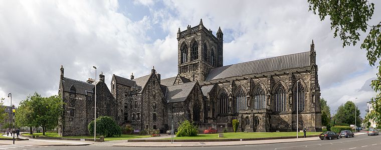
Photo: Colin, CC BY-SA 3.0.
Paisley Abbey is a parish church of the Church of Scotland on the east bank of the White Cart Water in the centre of the town of Paisley, Renfrewshire, about 7 miles west of Glasgow, in Scotland. Paisley Abbey is situated 1,200 feet southeast of Paisley Gilmour Street.
St Mirin’s Cathedral
Church

Photo: Wikimedia, Public domain.
The Cathedral Church of Saint Mirin in Paisley, dedicated to Saint Mirin the patron saint of Paisley, is the mother church of the Catholic Diocese of Paisley and is the seat of the Bishop of Paisley. St Mirin’s Cathedral is situated 1,600 feet east of Paisley Gilmour Street.
Places in the Area
Nearby places include Paisley and Ralston.
Paisley

Photo: Colin, CC BY-SA 3.0.
Paisley is a town in Renfrewshire, on Clydeside in the Central Belt of Scotland, with a population of 79,40 in 2020. It was a major centre for textiles, mass-producing "Paisley pattern" fabrics, though all the mills are long gone.
Ralston
Suburb
Ralston is a small, middle-class, suburban settlement in Renfrewshire, Scotland, being part of the greater town of Paisley. The district straddles the A761, the main dual-carriageway between Renfrewshire and the City of Glasgow. Ralston is situated 1½ miles east of Paisley Gilmour Street.
Penilee
Suburb
Penilee is a small housing scheme and suburb on the southwestern edge of Glasgow, Scotland. The area is bounded to its east by the Glasgow suburbs of Cardonald and Hillington, and to the west by the Renfrewshire border and the farms of North and South Arkleston. Penilee is situated 2 miles east of Paisley Gilmour Street.
Paisley Gilmour Street
- Type: Railway station
- Categories: building and transportation
- Location: Renfrewshire, Scotland, United Kingdom, Britain and Ireland, Europe
- View on OpenStreetMap
Latitude
55.84733° or 55° 50′ 50″ northLongitude
-4.42422° or 4° 25′ 27″ westOpen location code
9C7QRHWG+W8OpenStreetMap ID
way 58779528OpenStreetMap feature
building=train_station
This page is based on OpenStreetMap, Wikidata, and Wikimedia Commons.
We’d love your help improving our open data sources. Thank you for contributing.
Satellite Map
Discover Paisley Gilmour Street from above in high-definition satellite imagery.
Places with the Same Name
Discover other places named “Paisley Gilmour Street”.
Notable Places Nearby
Highlights include County Square and The Piazza.
Nearby Places
Explore places such as Gilmour Street Station Taxi Rank and Paisley Central Rd/ Stop 3 Central Rd.
Scotland: Must-Visit Destinations
Delve into Edinburgh, Glasgow, Aberdeen, and Dundee.
Curious Railway Stations to Discover
Uncover intriguing railway stations from every corner of the globe.
About Mapcarta. Data © OpenStreetMap contributors and available under the Open Database License". Text is available under the CC BY-SA 4.0 license, except for photos, directions, and the map. Photo: Ritchyblack, FAL.