سمر الهامس
سمر الهامس is a pharmacy in Rif-dimashq Governorate, Syria. سمر الهامس is situated nearby to the hospital مشفى الرعاية الخاصة, as well as near Al-Rawda Square.| Tap on a place to explore it |
Places of Interest Nearby
Highlights include Bab ash-Sharqi and Bab Touma.
Bab ash-Sharqi
City gate

Photo: Bgag, CC BY-SA 3.0.
Bab Sharqi, also known as the Gate of the Sun, is one of the seven ancient city gates of Damascus, Syria. Its modern name comes from its location in the eastern side of the city. Bab ash-Sharqi is situated 3 km northwest of سمر الهامس.
Bab Touma
City gate
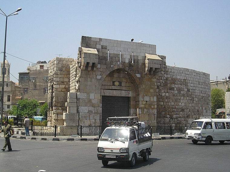
Photo: Heretiq, CC BY-SA 2.5.
Bab Tuma is a neighborhood located in the Old city of Damascus in Syria. It is one of the seven gates of Damascus, a geographic landmark of Christianity. Bab Touma is situated 3½ km northwest of سمر الهامس.
Bab Kisan
City gate

Photo: Heretiq, CC BY-SA 3.0.
Bab Kisan is one of the seven ancient city-gates of Damascus, Syria. The gate, which is now located in the southeastern part of the Old City, was named in memory of a slave who became famous during a conquest by the Caliph Mu'awiya. Bab Kisan is situated 3 km northwest of سمر الهامس.
Places in the Area
Nearby places include Damascus and Irbin.
Damascus

Photo: علي الصمادي, CC BY-SA 3.0.
Damascus is the capital and largest city of Syria. A city of immense historical importance, Damascus was the capital of the Umayyad Caliphate during the Islamic Golden Age.
Irbin
Town
Arbin is a town in southern Syria, administratively part of the Markaz Rif Dimashq District of the Rif Dimashq Governorate, located just east of Jobar neighborhood of Damascus. Irbin is situated 6 km north of سمر الهامس.
Abu Jarash
Quarter
Abu Jarash is a neighborhood and district of the al-Salihiyah municipality of Damascus, Syria. It had a population of 12,798 in the 2004 census. In the 1936 French Mandate census, Abu Jarash had a population of 9,600, all Muslims. Abu Jarash is situated 6 km northwest of سمر الهامس.
سمر الهامس
- Type: Pharmacy
- Category: health care
- Location: Rif-dimashq Governorate, Syria, Middle East, Asia
- View on OpenStreetMap
Latitude
33.48982° or 33° 29′ 23″ northLongitude
36.34297° or 36° 20′ 35″ eastOpen location code
8G5RF8QV+W5OpenStreetMap ID
node 5679863324OpenStreetMap feature
amenity=pharmacy
This page is based on OpenStreetMap, Wikidata, and Wikimedia Commons.
We’d love your help improving our open data sources. Thank you for contributing.
Satellite Map
Discover سمر الهامس from above in high-definition satellite imagery.
Notable Places Nearby
Highlights include مشفى الرعاية الخاصة and Al-Rawda Square.
Nearby Places
Explore places such as صيدلية شادي عبود and صيدلية الوحدة.
Syria: Must-Visit Destinations
Delve into Damascus, Aleppo, Syrian Desert, and Golan Heights.
Curious Pharmacies to Discover
Uncover intriguing pharmacies from every corner of the globe.
About Mapcarta. Data © OpenStreetMap contributors and available under the Open Database License". Text is available under the CC BY-SA 4.0 license, except for photos, directions, and the map. Photo: Yvonnefm, CC BY-SA 3.0.