ASDA Fueling Station
ASDA Fueling Station is a gas station in Angus, North East Scotland, Scotland. ASDA Fueling Station is situated nearby to the forest The Roundie, as well as near the town hall Muirhead & Birkhill Millenium Hall.| Tap on a place to explore it |
Places of Interest Nearby
Highlights include Camperdown House and Backmuir Wood.
Camperdown House
Historic building

Photo: Wikimedia, CC BY-SA 3.0.
Camperdown House is a historic building, which is situated 3,800 feet southeast of ASDA Fueling Station.
Backmuir Wood
Forest
Backmuir Wood is a 140.58 acres woodland in the Scottish county of Angus, about 4 kilometres northwest of Dundee. It is located south of the A923, between the villages of Muirhead and Liff.
Dundee Ice Arena
Ice rink
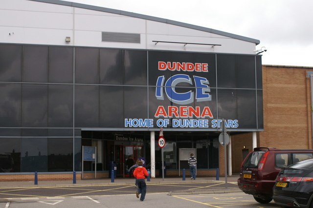
Photo: Mike Pennington, CC BY-SA 2.0.
Dundee Ice Arena, a multifaceted ice rink facility, is situated in the Camperdown locality of Dundee, Scotland. Boasting a seating capacity of 2,400, it ranks as the fourth largest ice rink in Scotland, surpassed only by Braehead Arena, Murrayfield Ice Rink, and Fife Ice Arena. Dundee Ice Arena is situated 1¼ miles southeast of ASDA Fueling Station.
Places in the Area
Nearby places include Birkhill and Liff.
Birkhill
Village

Photo: James Allan, CC BY-SA 2.0.
Birkhill and neighbouring Muirhead are two small villages in Angus, just to the west of Dundee, Scotland.
Liff
Village

Photo: Wikimedia, CC BY-SA 4.0.
Liff is a town in Angus, Scotland, situated 4+1⁄2 miles west-northwest of Dundee on a south-facing slope two miles north of the River Tay. It had a population of 568 in 2011.
Charleston
Suburb
Charleston is an area on the northwest edge of Dundee, Scotland. Menzieshill is to the immediate southwest, Camperdown borders it to the north, and Lochee is to the east.
ASDA Fueling Station
- Type: Gas station
- Also known as: “Esso”
- Categories: building, canopy, and transportation
- Location: Angus, North East Scotland, Scotland, United Kingdom, Britain and Ireland, Europe
- View on OpenStreetMap
Latitude
56.49301° or 56° 29′ 35″ northLongitude
-3.05355° or 3° 3′ 13″ westOpen location code
9C8RFWVW+6HOpenStreetMap ID
way 761528422OpenStreetMap feature
amenity=fuelOpenStreetMap feature
building=roof
This page is based on OpenStreetMap, Wikidata, and Wikimedia Commons.
We’d love your help improving our open data sources. Thank you for contributing.
Satellite Map
Discover ASDA Fueling Station from above in high-definition satellite imagery.
Notable Places Nearby
Highlights include The Roundie and Muirhead & Birkhill Millenium Hall.
Nearby Places
Explore places such as Post Box Road and Asda Express.
Angus: Must-Visit Destinations
Delve into Dundee, Forfar, Arbroath, and Montrose.
Curious Gas Stations to Discover
Uncover intriguing gas stations from every corner of the globe.
About Mapcarta. Data © OpenStreetMap contributors and available under the Open Database License". Text is available under the CC BY-SA 4.0 license, except for photos, directions, and the map. Photo: Wikimedia, CC0.